What is a Spatial Data Infrastructure and why do we need one?
An SDI can be described as a framework of technologies, policies and different arrangements that supports the creation, use and exchange of geospatial data and related information across different business interfaces.
At Sterblue location is a core aspect. Location makes it possible to perform precise trajectories, generate accurate orthophotos, extract the real position of possible anomalies and much more. Because of this, location is present on the data we collect, the data we process, in our analysis and on the products we deliver to the final users. We call these information geospatial data.
In order to store and process these location data we must have a proper infrastructure that is able to support geospatial data consistently with geospatial standards, capabilities and enough power that enable us to integrate it with our products.
Location based services are essential to give many answers which we’ll try to gradually cover in this article.
Sterblue’s Spatial Data Infrastructure (SDI)

At Sterblue we strive to be always updated with the latest stable science innovations and state-of-the-art technologies. Besides, we believe that open source and collaborative tools add extra value to our business. Hence, our SDI has a central database (DB) implemented on PostgreSQL with PostGIS. This powerful DB directly integrates the geospatial capabilities tools required to exploit the geospatial nature of our data.
A GraphQL Application Program Interface (API) generated by PostGraphile with PostGIS support acts as the main access hub on top of the DB. This PostGIS support on GraphQL means most of the queries can become fully spatial when needed, either 2D or 3D. This means the API, apart from simply accessing data, also has the ability to input spatial data; perform spatial analysis and output spatial results. Allying GraphQL with spatial capabilities is a very innovative solution. Having more than ten years of experience on configuring SDI’s, I’m very surprised and enthusiastic about it’s simplicity in terms of configuration, usage and the robustness of this approach.
Standards
Everyone that works with geospatial data and SDI’s is aware of the importance of Open Geospatial Consortium (OGC) standards. Using OGC standards Sterblue ensures data interoperability across different spatial softwares and platforms. For this reason, we are currently implementing an access point parallel to GraphQL API which allows an end user to use common OGC web services, namely Web Feature Service (WFS); Web Map Service (WMS); Web Map Tile Service (WMTS) and 3D Tiles (for internal use only). In the future we might also have Web Coverage Service (WCS) for imagery data.

Security
Concerning security, Sterblue uses PostgreSQL Row Level Security (RLS) directly at the database level to guarantee security for each user. Then, users are able to see only their own data in all our products and access points, ensuring data consistency on the database. Besides, users benefit from RLS by using the same credentials, i.e. username and password, for the different products regardless the access point used, e.g., our GraphQL API; OGC services or web platform.
What is a Geographic Information System (GIS)?
GIS uses geospatial science and location based tools to understand and get knowledge from different kinds of data and facilitate collaboration.

A classical GIS can be defined as a conceptual framework that provides the ability to:
- Capture geospatial data,
- Integrate different kinds of data layers using their location. These data usually come from different data sources and formats such as imagery (satellite, drones, helicopters, smartphones); features (roads, powerline networks) and even spreadsheets and tables linked to basemaps.
- Analyze these data using spatial awareness capable of predict, estimate, interpret and understand real world problems in order to help the decision making process.
- Display results in an easy way that everyone (tech and non-tech) can understand and that can virtually work on every platform.
How is Sterblue using this technology?
Sterblue uses SDI with GIS capabilities in many different ways to cover different purposes.
The most obvious examples are the structures inspected, which can be either wind turbines, distribution poles, transmission towers, cooling towers just to name a few. All structures are properly captured and stored with their geospatial properties. Making it possible to integrate them with all different kinds of data such as point clouds, satellite imagery or even other products such as land cover data or vegetation maps. All structures can be displayed and integrated with other datasets using Sterblue world platform as shown in Figure 4. Alternatively they can also be spatially queried in our GraphQL API. In the near future they could be displayed in any OGC standards compliant GIS software such as ArcGIS or QGIS.

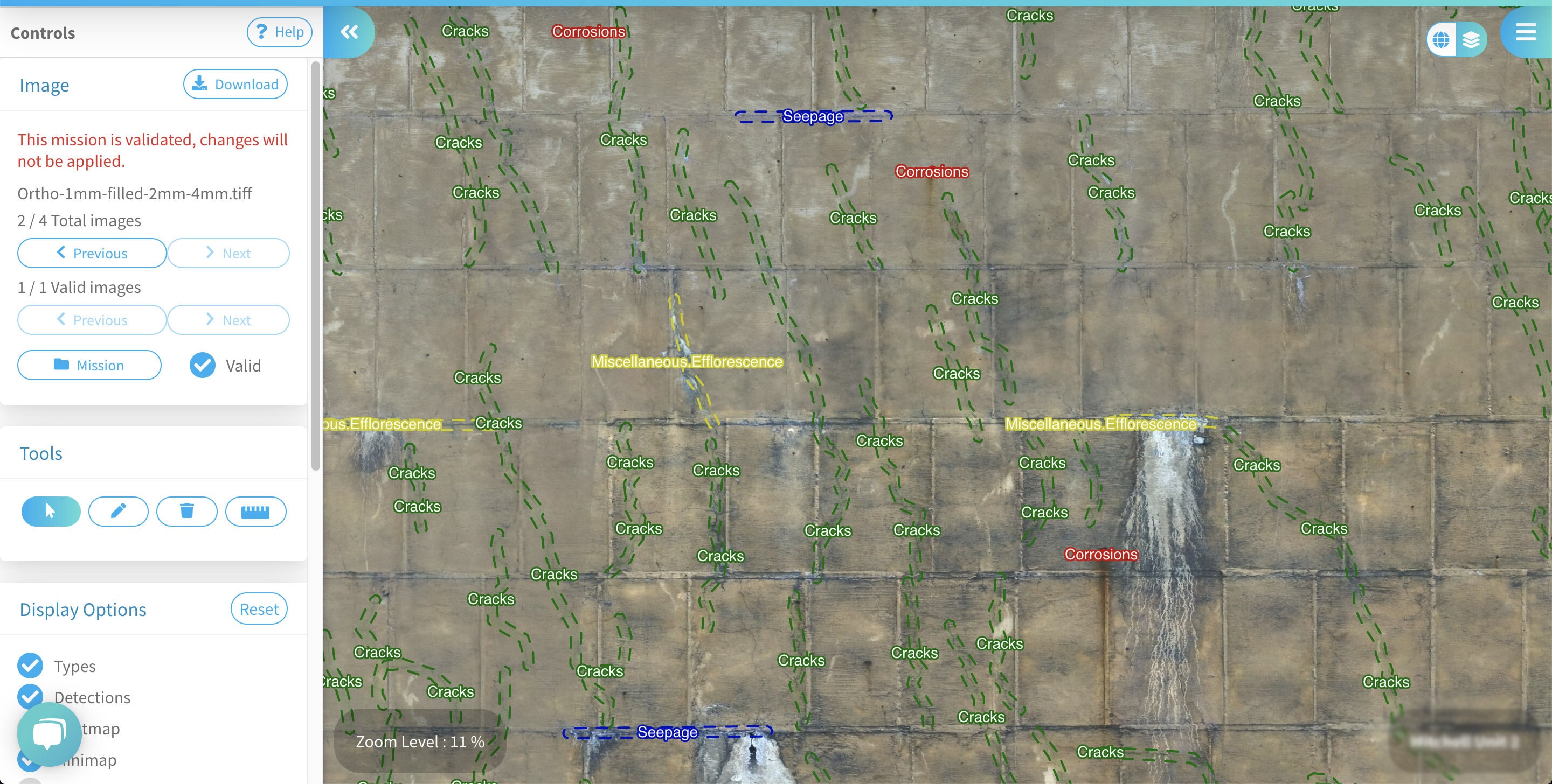
Other examples are the anomalies detected during inspections. As shown in Figure 5, detections are managed as GIS features, which allows us to properly store them and for example avoid invalid geometries. We also integrate and analyze these anomalies, for example, by measuring their size, area and possible overlaps. And finally, we display them using any GIS software such as QGIS or a web mapping platform such as Sterblue Cloud.
OpenStreetMap data integration
OpenStreetMap (OSM) is a collaborative project where anyone can contribute to produce a world map. Similar to Wikipedia, where anyone can contribute by adding content, OSM provides a global map based on collaboration. OSM data are available under the Open Database License, meaning Sterblue can freely use and integrate it with our datasets. Datasets such as global road networks, local infrastructures and global power networks for example, are integrated into our GIS. Then, we can benefit from this information, not only for internal purposes by our Operations Team, but also for our clients. For example, through our platform, our users can query for road proximity, global power infrastructures proximity, presence of airports or aerodromes in the surroundings. This is particularly useful in remote areas where the official spatial data does not provide sufficient details.
Remote sensing
According to the United States Geological Survey (USGS), remote sensing is the process of detecting and monitoring characteristics of an area using its reflected and emitted radiations at a distance, thanks to sensor data collected by satellite, aircrafts or drones. Sterblue started as a drone based company, so it is easy to understand the importance of remote sensing to us.

Remote sensed imagery is an integrated component of Sterblue’s GIS. We are experts in collecting high resolution imagery using drones and integrating it in our GIS. Besides, we can also integrate external imagery from different private and public data sources such as Copernicus Access Hub (Sentinel satellite data), Copernicus land service products (e.g. Corine land cover), USGS Earth Explorer (Landsat satellite data), and other global and local data hubs. This allows us to accurately map and extract several earth characteristics such as land cover classification, land cover changes, vegetation detection and classification.
Why are these tools important to our business, how can our clients benefit?
In order to answer this question let’s focus on some of the possible topics Sterblue can directly address with this technology.
Vegetation detection
As previously mentioned, remote sensing can be useful in many ways namely detecting and classifying vegetation. Sterblue is able to accurately detect and classify vegetation at any location in the world, using satellite imagery analysis performed with self-developed algorithms and datasets from different sources, when available. The accuracy of vegetation encroachment to a powerline or structure can be closer than 1 metre, varying a lot depending on external factors such as satellite resolution, the existence of auxiliary and complementary local data as well as its minimum mapping unit. We are also working on estimating elevation and volume of vegetation.

Detect Land cover changes
Land cover classification and change detection is another topic deeply related to vegetation. Using Sterblue’s GIS, an end user can easily answer the following questions:
- What are the current land uses under or in the surroundings of a structure?
- Has there been any land cover change in the surroundings of a structure?
- When and where the latest land cover change happened in the surroundings of a structure?
Similarly to vegetation, the accuracy of this information may vary depending on the country, location and existence of auxiliary data and its resolution.
Integration with other datasets
It's possible to integrate your structures with existing datasets using Sterblue’s GIS. Whether using OSM datasets directly in our system, using our remote sensing products, or even using governamental datasets already integrated with Sterblue, such as the Portuguese land cover datasets, Carta de Ocupação de Solo (COS). Apart from what was previously mentioned, more examples of queries that a user can perform in our system (using our GraphQL API for example) can be:
- Are any of my structures close to a recent reported forest fire?
- Which year was the closest reported forest fire from my structures? How close?
- Where's the closest road?
- What are the nearest natural reserve or protected areas from my structure?
- Have there been any recent reported earthquakes close to my structures?
- Does a powerline cross a major water body?
- What are the closest OSM global power network structures?
These are just a few examples of an immense amount of questions our users can quickly see answered by our system.
Sterblue is constantly evolving in order to provide the best up-to-date solutions. By now it should be clear the importance of having a robust SDI and a powerful GIS. For our customers this represents a group of several products and functionalities they can benefit when acquiring Sterblue services.
